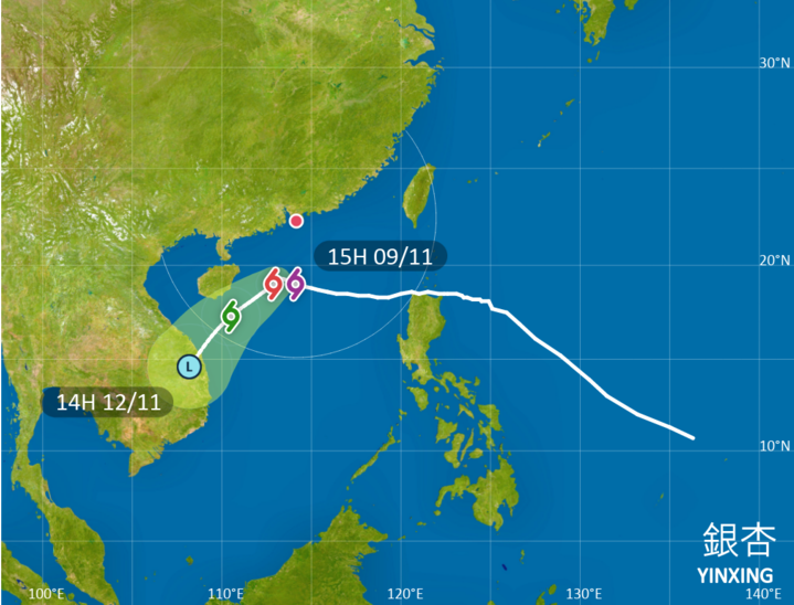
HONG KONG – The Hong Kong Observatory issued the Strong Wind Signal, No 3 at 3:40 pm on Saturday as Super Typhoon Yinxing edged closer to the city.
The signal, which means that winds with mean speeds of 41 to 62 kilometers per hour are expected, will remain in force at least until 10 am on Sunday, the HKO said in a 3:45 pm bulletin.
READ MORE: T1 signal issued as cyclone Yinxing edges closer to HK
In the past couple of hours, Yinxing, which has a compact circulation, maintained its Super Typhoon intensity and gradually edged closer to the coast of southern China, according to the bulletin.
Under the combined effect of Yinxing and the northeast monsoon, winds generally over the territory are expected to strengthen gradually, with winds on high ground occasionally reaching gale force, it said, adding that there will also be a few squally showers.

At 4 pm, Yinxing was estimated to be about 370 km south of Hong Kong and is forecast to move west-northwest at about 10 km per hour across the northern part of the South China Sea.
According to the present forecast track, Yinxing will skirt more than about 300 km to the south of the territory Saturday night to Sunday morning.

“Unless Yinxing adopts a more northerly track closer to the Pearl River Estuary, the chance of issuing higher tropical cyclone warning signals will be rather low,” reads the HKO bulletin.
The observatory forecast Yinxing will gradually turn southwestwards away from the coast of Guangdong on Sunday.
ALSO READ: Waterspout appears over Victoria Harbor for first time since 1959
Depending on the degree of weakening of local winds, the observatory will then consider issuing the Standby Signal, No 1.
The HKO issued the Standby Signal, No 1 at 12:40 pm on Friday. A tropical cyclone warning signal is expected to remain in force until Sunday morning.


